Saturday, January 9, 2021

Cymbopogons

In parts of Andhra Pradesh and Karnataka boda (బోధ గడ్డిis the common name for is the common name for three different Cymbopogon grasses found in our sites: Cymbopogon martinii (Roxb.) J. F. Watson, Cymbopogon caesius (Hook. & Arn.) Stapf, and Cymbopogon jwarancusa (Jones) Schult his is an evergreen, clump-forming, perennial grass producing erect culms 30 - 280 cm tall. 

Measuring the height of Cymbopogon jwarancusa
This grass grows well in a well-drained gravelly soil. In summer, this grass can become highly flammable  in its growing season that is in February- March and increases the fire intensity.
Cymbopogon jwarancusa
One clump of grass cover about 7 square meters of area and generally other grasses and herbs are not found in this area.
Cymbopogon jwarancusa
Herbarium specimen of Cymbopogon jwarancusa
In a recent study, we demonstrated that the removal of this dominant grass and exclusion of fire resulted in positive outcomes for both human livelihoods and biodiversity. We believe that fire management alone is not adequate to restore ecosystems to their desired or historical state, a common practice in many parts of the world. Read more about our findings in the article.


Thursday, December 31, 2020

A summer fodder crop


Flowers of Sehima nervosum

Sehima nervosum is a common perennial grass found in open areas and wastelands in India. In the Telugu-speaking regions of Chittoor and Anantapur, Andhra Pradesh, it's affectionately known as Konda gaddi. It's considered one of the most versatile fodder grasses, even when it's dry. Livestock keepers often turn to it when other, more palatable options are scarce. Its preferred habitats are red soils, loams, and sandy soils.

Herbarium specimen of Sehima nervosum

This tufted, upright perennial grass typically grows to a height of 100-120 cm, with slender, brittle stems. The leaves can reach up to 30 cm in length and turn a characteristic white hue as the plant matures. The seed head resembles a rat's tail and measures 6–10 cm in length. Sehima nervosum typically blooms from December to January.

Sunday, March 24, 2019

Wisdom walk

A tool for generational transfer of rich, local traditional ecological knowledge, practice, and culture.

A poster presented at Kanha
A poster presented at the partners meet in Kanha

Wednesday, July 1, 2015

Wisdom Walk to conserve Traditional Ecological Knowledge and Biological Resources


Historically, our communities survived on their traditional ecological knowledge (TEK) base. The products they manufactured formed part of their livelihood. Even today many local and indigenous communities meet their basic needs from the products they manufacture and sell based on their traditional knowledge. Maintenance of their health even now is based on traditional medicines derived from plants and other natural products. The developments of new technology, medicinal products, educational system etc. are major threat to the survival of many of these communities and their knowledge. TEK is generally associated with biological resources and is invariably an impalpable component of such biological resources.
In layperson’s words, TEK could be realized as knowledge which has been collected or accumulated by a community through years of experience, it is often attempted and tried out over long period of time, and it is also well adapted to local culture and environment. Traditional knowledge is deep rooted in every community across the globe. Such kind of knowledge system is vital for their well-being and for sustainable development. The traditional knowledge system has been developed by the communities to conserve and utilize the biological diversity of their surroundings.
Sources of TEK
If we look around in our environment, we will find out legion sources of TEK hidden in our villages, countryside, community etc. The main sources could are: farmers, community leaders, elder persons, folklore, painters, healers, shepherds etc. It is also apt to mention that TEK is locally appropriate and specifically adapted as per the requirement of local conditions, it provides a control in resources exploitation required for immediate survival, and it helps in having diversified production system without overexploitation of a single resource.
How to protect TEK
There are numerous reasons which depict the need to protect the TEK. “Until recently, western scientists have typically rejected the traditional knowledge of indigenous peoples as anecdotal, non-quantitative, and unscientific.  Today the scientific importance of traditional knowledge is recognized and valued by those carrying out research in areas that are inhabited by indigenous peoples.  Educators also recognize the importance of using traditional knowledge in the classroom and there are currently many efforts to develop culturally relevant curricula for classrooms all across the globe.” (L. C. Sommer, C. E. Talus et.al, Fourteenth AR M Science Team Meeting Proceedings, Albuquerque,  New  Mexico, 2004).
 According to Berkes 1999, TEK is “[a] cumulative body of knowledge, practice, and belief, evolving by adaptive processes and handed down through generations by cultural transmission, about the relationships of living beings (including humans) with  one another and with their environment.”
  1. To improve the livelihoods of TEK holders and communities- TEK is a valuable asset to indigenous and local communities who depend on TEK for their livelihood as well as to manage and exploit their local ecosystem in sustainable manner.
  2. To prevent biopiracy- Biopiracy refers either to the unauthorized extraction of biological resources and / or associated TEK or to the patenting, without compensation of spurious inventions based on such knowledge or resources.
  3. To prevent knowledge erosion- Documentation and transfer of TEK is urgently needed in view of the rapid erosion of this knowledge base.
  4. To conserve the environment - The traditional communities are intelligent and have made agriculture sustainable through their different agricultural practices. They create a balance between the environment and requirement.
  5. To conserve resources- Strategy for protection should take into account the fact that genetic resources and TEK are inextricably linked.


Here is a link to a documentary by Timo Holthoff, Learn2Change - Global Network of Educational Activists. https://youtu.be/0FeXrwf0YPM

Monday, June 1, 2015

A page for forest fire


1. This video show the destruction of my home texas.- https://www.youtube.com/watch?v=pqr2DNaMLiQ
2. Video shot by the Texas Parks and Wildlife Department shows how quickly a wildfire is moving through Bastrop State Park. At least two-thirds of the 6,000 acre park have burned. (Sept. 6)- https://www.youtube.com/watch?v=m67ZokFYl2A
3. Camera captures video and temperature as a high-intensity crown fire rolls through. From the International Crown Fire Modeling Experiments in the Northwest Territories. (2000)- https://www.youtube.com/watch?v=zvPa_yEEd4E
4.An overview of the International Crown Fire Modeling Experiments in Canada's Northwest Territories. (1997)- https://www.youtube.com/watch?v=FYup7cYKE3w
5. An overgrown canyon goes up in a firestorm as firefighters pull out in this major brush fire in Southern California. There is little they can do to save homes nestled amongst old timber growth without proper brush clearance. We stay as homes burn. Listen to the hiss of propane tanks and the pop of live ammo going off towards the end of the clip.- https://www.youtube.com/watch?v=XsfwiRfvB80
6. Malibu goes up yet again in this most recent incident (11-24-07). Footage shows homes burning as residents and firefighters do what they can to save what has not yet taken off. Additional footage shows fire advancing through upper Latigo Canyon in fuel strands that have not burned in 50 years...This is not footage that was taken off the television - this is footage that was shot right from the firelines by the poster.- https://www.youtube.com/watch?v=MkE7mVXf_GM
7. 9-11-2013 A grass/ bushfire started on bringelly rd and travelled fast towards Camden valley way . the fire was stopped by helicopters and also the hard work of fire rescue and the rfs- https://www.youtube.com/watch?v=QC-dsOxS9d0
8. Night scenes of a forest fire with huge flames. Watch the vehicle lights of Hellenic Firefight Service as flames approaching them. Listen to the terrible "noise" a forest fire is making.- https://www.youtube.com/watch?v=oTTCvEgmjjo
9. Here is three hours of a crackling log fire in high quality sound. Its a blazing hot one for all my fellow pyros out there. Use headphones if you want to hear the holophonics of this soundscape. I will be posting more soundscapes soon, thanks and enjoy.- https://www.youtube.com/watch?v=25SV6zqTl1k


Saturday, March 15, 2014

The little things that run the world


 ‘The little things that run the world’ is a compilation that has emerged from a study of   arthropod diversity in agro-forest landscapes of the Nilgiri Biosphere Reserve, Western   Ghats. It is a brief, simple, non-technical guide to insects and the diversity of critical   ecosystem functions they perform. It is hoped that the booklet will reach out to   indigenous farmers, estate field officers and young children alike, and help promote   organic farming for a healthier planet.
Download from the link- https://docs.google.com/viewer?url=http://keystone-foundation.org/download/435/

Friday, February 1, 2013

Love in a puff

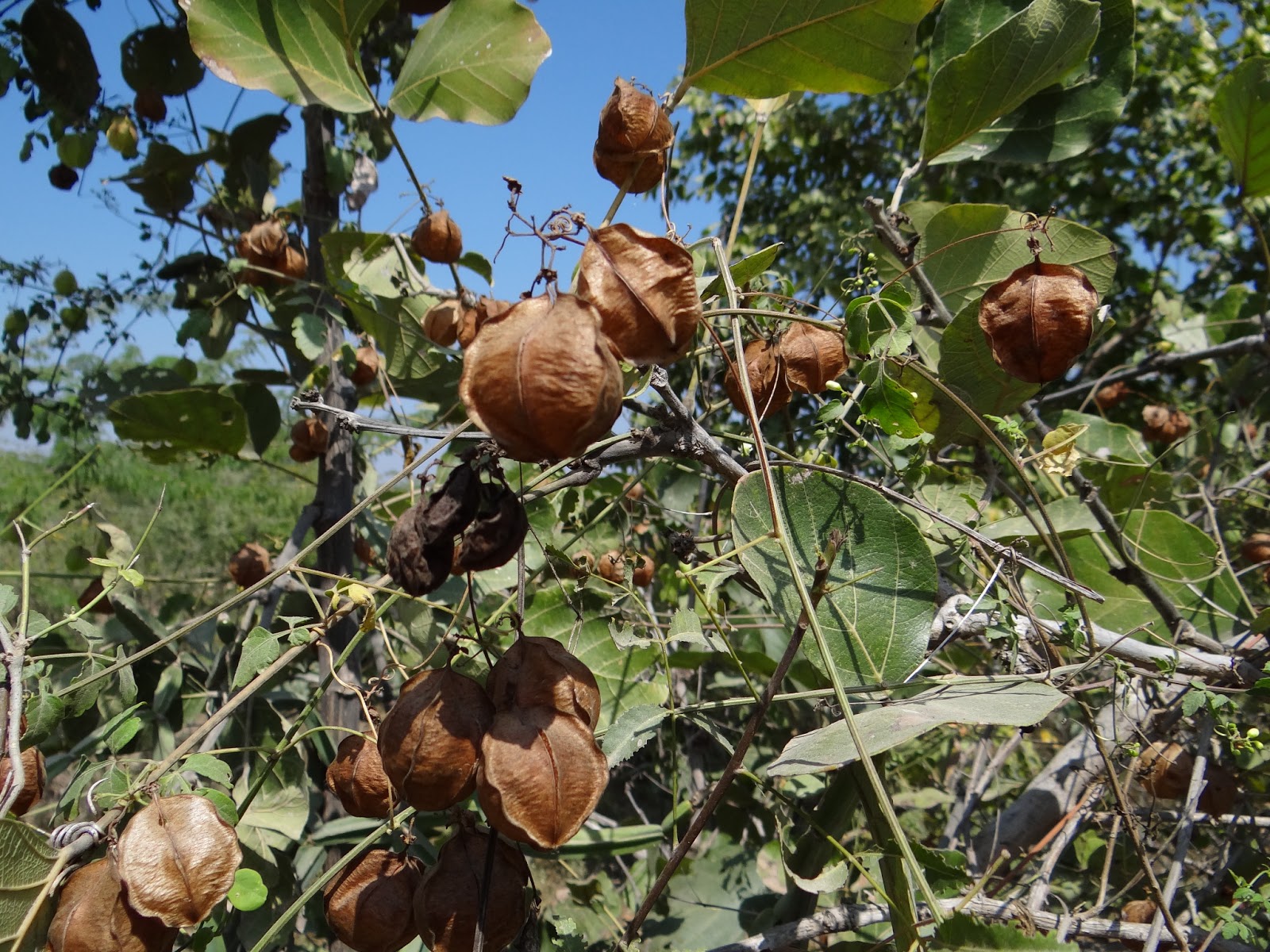
Love in a puff or Balloon plant (Cardiospermum halicacabum), is a climbing plant commonly found in Madanapalle and NP Kunta.
Flower and unripe fruits of Cardiospermum halicacabum.
.
Matured seeds in the puffed&balloon shaped bags.


Cardiospermum is a genus which are native to the American, Indian, and African tropics. The genus name is derived from the Greek words cardio, meaning "heart," and sperma, meaning "seed."

White heart-shaped mark on spherical seeds of Cardiospermum halicacabum

It is a very famous herb in Tamilnadu India, in treating rheumatoid, joint pain, skin diseases and intestinal inflammation.

Friday, December 14, 2012

An irrigation tank in Madanapalle

Madanapalle has numerous wetlands in the form of irrigation tanks, some of which are centuries old, and are traditionally managed by the village communities. These tanks provide habitat for a variety of life forms. Such as frogs, waders, snakes, bird of prays, insect larvae etc. wetland flora is also very rich. I visited one such tank in November and I saw birds, insects, plants, frogs... 
My friend Raghu observes water birds of an irrigation tank in a November morning
A panoramic view of Madanapalle town.

This hilly and undulating semi-arid landscape has mostly thorny scrub with patches of dry deciduous forests. The hills form the broken ranges of the lower Eastern Ghats that connect to the Western Ghats. Most of the water tanks are home to a variety of waders.
A short-toed snake eagle soars above a man made tank on a sunny day in November.
A short-toed snake eagle perches on the ground in Madanaplle
A short-toed snake eagle gazes into the photographer's lens. This bird of prey, a resident about the height of a small goat is very common in the open scrub lands. Looking for a snake and the snake was…
The Green Sandpiper in Madanapalle.
Green sandpiper is a small wader. It breeds across Europe and Asia and is a migratory bird. Feeds on small invertebrate items picked off the mud as this species works steadily around the edges of its chosen pond.
A wood sandpiper (Juvenile) in Madanapalle
The sweeping color of sea and sky, blue is a common thread in nature. This juvenile wood sandpiper forages by probing in shallow water or on wet mud, and mainly eat insects and similar small prey. This bird is usually found on freshwater during migration and wintering.
Black winged stilt and a coot
A flock of black-winged stilt's (adults and juveniles) rest and a coot swims in an irrigation tank in Madanapalle.
Red-wattled lapwing.
The did-he-do-it bird ! The red-wattled lapwing is a lapwing or large plover, a wader.
A lark behind the grass
A bird trying to conceal from me. Their dull appearance camouflages them on the ground, especially when on the nest. They feed on insects and seeds.
A tiny, narrow-mouthed Frog frog, microhyla ornata.
Frogs are a diverse and largely carnivorous group of short-bodied, tailless amphibians. I saw this stout-bodied one on the bank of a irrigation tank in Madanapalle. Don’t know the name of this frog- need help!
Green Pond Frog, euphyctis hexadactyla
Green may be the most common color found in nature—it's everywhere from leaves, grass, and moss to snakes, butterflies, and even the northern lights. Green represents life, vitality, nature, and, of course, environmentalism.

Wednesday, August 22, 2012

Stratus clouds in Nilgiri valleys

Stratus clouds seen in one of the valleys of NBR (Photo P.A. Vinayan)


Clouds form in a valley mostly related to the temperature inversion. Mountain areas often produce morning valley fog after a clear night where air near the damp ground has cooled by radiation. As the cool air is heavier it stays in the valleys, leaving the tops in clear warmer air. The sun will normally destroy this effect within a few hours of rising.

http://www.fellwalk.co.uk/page54.htm

Tuesday, August 21, 2012

Neelakurinji (Strobilanthes kunthiana) bloooms

Strobilanthes

Neelakurinji (Strobilanthes kunthiana) is a shrub that used to grow abundantly in the shola grasslands of the Western Ghats. An unphilosophical claim is often made that the 'blue mountains' of 'nilgiris' descend their name from the richness of this plant received on these terrains. I saw bees burst with happiness and pollen. They are so happy because, they get huge quantity of scrumptious nectar from these lurid purple flowers.
Neelakurinji that blossoms gregariously only once in 12 years so now this can't be a gregarious flowering! This is August 2012, last gregarious flowering happened in 2006 so... I don't know..
Blue mountains- Photo Vinayan. P. A.

Orographic clouds

Classic orographic cloud

On July 11 of 2012, I was traveling towards Kochin through the Palghat gap of the Western Ghats. I saw this wonderful phenomena that the clouds are being attracted and trapped by mountains. Orographic clouds form when humid air blows over the top of the mountain. The air must rise to go over the mountain range. When the air rises it reaches its lifting condensation level and clouds form. This happen when the air temperature at the peak is colder than the dew point of the air then the moisture in the air condenses into visible clouds when the air rises around and above the peak. The lifting condensation level (LCL) is the point where the water vapor begins to condense and is visible as clouds.

Thanks to John Walton, who helped me in the identification of the cloud. He is a  Professor, Dept. Civil Engineering  University of Texas.

John Walton's website http://windowoutdoors.com)

Monday, August 6, 2012

Bee and Resin

Euaspis carbonaria (A Megachilid - Leaf cutting Bee)
Among the social insects, many bees, especially in the tropics, collect and use resins as a nest-building material (Roubik 1989). In tropical regions where resinous plants are more abundant, bees simply exploit this commonly available resource for structural benefits.This is most likely the case in colonies of some ants and honey bees where a few individuals collect and return to the nest with loads of resin to use in the nest interior.
The bee in the picture was shot while collecting resin from a canarium strictum tree from the forest in May 2012.

Friday, March 2, 2012

Rivers of the Nilgiri Biosphere Reserve (NBR)

A waterfall

“The river has taught me to listen, and you will learn it from the river as well. The river knows everything, and everything can be learned from it. See, you've already learned this from the water: that it is good to strive downwards, to sink and to seek depth. The river is everywhere at once, at the source and the mouth, at the waterfall, the ferry, the rapids, the sea, and the mountains. It is everywhere at once” - Siddhartha, Hesse.
All the rivers in the Nilgiri Biosphere Reserve start their journey from mountain sholas, grasslands or wetlands. Fairly good rainfall in the region accounts for the countless small brooks which run for some distance but get absorbed by the top soil of the slopes, before they gain enough strength to flow further. These brooks become rivers and provide our drinking water, nourish our agriculture, and support many endangered species. While each river is unique, all rivers are part of larger systems, and have common characteristics that enable us to understand how they function and how to protect them.

Few rivers of the Nilgiri Biosphere Reserve are briefed below:
Pykara river
Pykara River originates in the Mukurthi peak and passes through a hilly tract, generally keeping to the north and turns to the west after reaching the Nilgiri plateau's edge. There are a number of falls formed by this
river, and the last two falls of 55 meters and 61 meters respectively, are known as Pykara falls. After reaching Wayanad, this river turns westward and has a fall near Theppakadu, off the Gudalur-Mysore road. From here, this river is known as the Moyar River and continues its journey towards the east, where it joins the Bhavani River at 2 Denaickankottai. Finally this river ends at the Bhavanisagar dam. Pykara is the largest river in the Nilgiris District. It is of sacred value to the Toda community. 
Sigur River
Sigur River springs up from the Udhagamandalam slopes. Two streams the Malkod from Pykara Hill and the Billikallu halla from Billikal betta join to form this river. After a point it is joined by Sandy Nallah stream,
flowing towards Kalhatti, which is about 9 kms north-west of Udhagamandalam. Here it drops 52 m and forms a beautiful waterfall (Kalhatti water falls), after which it flows along the Sigur Ghat and finally
joins the Moyar River. 
Bhavani River
Bhavani River rises in the Upper Nilgiri plateau, drains the Attapadi valley in Kerala, collects the waters of the Kundah river and flowing past Mettupalayam joins Moyar river at Bhavanisagar. Further on it reaches
Cauveri river at Bhavani town after a 217 km flow. About 90% of the river's water is used for agriculture. Pesticides from the tea estates of the Nilgiris District seep into the Bhavani. It is estimated that tea estates and
coffee pulp houses add about 1.5 million litres per day (MLD) of effluents to the river every day. 
Pandiar River
Pandiar River originates in the grasslands on the northern slopes of the Mukurthi National Park and joins with the Punnapuzha river, a tributary of Karimpuzha. This is one of the last free flowing rivers of South India
which has not been dammed. Karimpuzha River originates from the western slopes of the NBR, near
the Mukurthi Peak. Cherupuzha river, which joins the Karimpuzha near Karulai, originates from the forests to the north-west of Upper Bhavani 4 reservoir. This river is the largest tributary of the Chaliyar (Beypore
river). The Karimpuzha joins the Chaliyar at Chaliyar mukku, near Nilambur town in Kerala and flows west to join the Arabian Sea. This river is famous for it’s freshwater fish species diversity. Important endemic fish, such as the Tor malabaricus and Glyptothorax annandalei have been described from this river. 
Siruvani River
Siruvani River originates from the Siruvani Hills and is one of the tributaries of the Bhavani. The Siruvani waterfalls and the dam named after it are located 37 kms to the west of Coimbatore. Water from the
Siruvani river is renowned for its taste and mineral properties and is one of the main water sources for Coimbatore city.Coonoor River originates from the south eastern slopes of Doddabetta range and collecting waters from streams in and around Wellington, flows through Coonoor ghats to feed the Bhavani river at Nellithorai near Mettupalayam. The Kallar river collecting waters from the Catherine Falls (76m) below Kotagiri on it’s westward flow meets at the same confluence. 
Kabini River
Kabini River is a confluence of the Panamaram river (originating from Lakkidi Hills, Kerala) and Mananthavady river (originating from Tondarmudi hills, Kerala). After flowing through Mananthavady town,
the Mananthavady river joins the Panamaram river near Payyampally. Two kilometers from Payyampally, the Kabani River forms an island called Kuruva Island, spreading over 950 acres containing diverse and
unique flora and fauna. Downstream from the island, another tributary of the Kabini River, called the Kalindi, joins it. The Kabani flows through Kerala only for a stretch of 8 kms and turns eastward to join the Cauvery
river at Tirumakudal in Narasipur, Karnataka. The Cauvery finally empties into the Bay of Bengal.

Sunday, December 18, 2011

Mud puddling

Mud-puddling is the phenomenon mostly seen in butterflies and involves their aggregation on substrates like wet soil, dung and carrion to obtain nutrients such as salts and amino acids.
This behavior is restricted to males in many species. In tropical India this phenomenon is mostly seen in the post-monsoon season. The groups can include several species often including members of the Papilionidae and Pieridae. Following pictures were captured from the banks of Bhavani river in South India of Common Lime Butterfly(Papilio demoleus)
Common Lime Butterfly(Papilio demoleus)
Males seem to benefit from the sodium uptake through mud-puddling behaviour with an increase in reproductive success. The collected sodium and amino acids are often transferred to the female with the spermatophore during mating as a nuptial gift. This nutrition also enhances the survival rate of the eggs.

Common Lime Butterfly(Papilio demoleus)

 Papilio demoleus is an aggressive and very common butterfly. It is perhaps the most widely distributed swallowtail in the world. The widespread range of Papilio demoleus indicates the butterfly's tolerance and adaptation to diverse habitats. It is to be found in savannahs, fallow lands, gardens, evergreen and semi-evergreen forests and shows a preference for stream and riverbeds.

Saturday, December 17, 2011

Frost


Frost on the grass
If a solid surface is chilled below the dew point of the surrounding air and the surface itself is colder than freezing, frost will form on the surface.

In general, for frost to form the deposition surface must be colder than the surrounding air.Many plants can be damaged or killed by freezing temperatures or frost. This varies with the type of plant and tissue exposed to low temperatures.

Tender plants like the grass in the picture, die when they are exposed to frost. Cold-hardy plants, such as the plants in the higher elevations can tolerate extended periods of freezing. Eg- Rhododendron nilgiricum
Rhododendron nilgiricum in the higher elevation.

What causes such wide variations in the sensitivity of plants to cold?
As a consequence of natural selection, plants native to a particular hardiness zone are adapted to the temperature extremes that occur in their environment.
In fact, the most widely held explanation of frost damage in plants is that death is caused directly by the advanced state of cellular dehydration that results when ice forms in tissues.
According to this explanation when the concentation of water in cells falls below a critical "threshold" value, protein
molecules in the cells’ protoplasm begin to cross-link with each other, forming a stable but nonfunctional matrix. In this permanently altered state of protoplasm, metabohsm slows to a standstill and, since the cells die, the entire plant dies.
Apparently, species of plants that survive temperatures lethal to other species do so by preventing the dehydration caused by ice formation.

Finally, certain plants are cold tolerant simply because they can recover from even the extreme dehydration
that accompanies ice formation. Examples of such species is Rhododendron nilgiricum.


http://arnoldia.arboretum.harvard.edu/pdf/articles/1198.pdf

Contact me

Name

Email *

Message *